Post-UTME Past Questions - Original materials are available here - Download PDF for your school of choice + 1 year SMS alerts
WAEC and NECO CBT Software for Computers and Laptops - Candidates, Schools, Centres, Resellers - 100% Offline -Download Now

Geography WAEC Past Questions

Clear Selections
Change Subject Post a Question Check Syllabus Study My Bookmarks Past Questions Videos Watch Video Lessons Download App

WAEC and NECO CBT App for Mobile Devices - Candidates, Schools, Centres, Resellers - 100% Offline -Download Now
WAEC and NECO CBT Software for Computers and Laptops - Candidates, Schools, Centres, Resellers - 100% Offline -Download Now
Your School's Whatsapp Group - Join Us now
1676

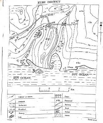
The scale of the map is

  • A. 1cm to +km
  • B. 1cm to 1km
  • C. 1cm to 2km
  • D. 2cm to 3km
View Answer & Discuss WAEC 2020
1677

The height at point P is about

  • A. 275m
  • B. 300m
  • C. 375m
  • D. 450m
View Answer & Discuss WAEC 2020
1678

The countour interval on the map is

  • A. 50m
  • B. 150m
  • C. 200m
  • D. 250m
View Answer & Discuss WAEC 2020
Post UTME Past Questions Agent
Post-UTME Past Questions - Original materials are available here - Download PDF for your school of choice + 1 year SMS alerts
Your School's Whatsapp Group - Join Us now
1679

What is the approximate distance from Obasa to Oju as the crowflies?

  • A. 10km
  • B. 18km
  • C. 20km
  • D. 25km
View Answer & Discuss WAEC 2020
1680

The bearing of Danki from Oju is

  • A. 90°
  • B. 150°
  • C. 285°
  • D. 355°
View Answer & Discuss WAEC 2020
Start a Free Practice Test
 
Your School's Whatsapp Group - Join Us now
WAEC and NECO CBT App for Mobile Devices - Candidates, Schools, Centres, Resellers - 100% Offline -Download Now
Post UTME Past Questions Agent
WAEC and NECO CBT Software for Computers and Laptops - Candidates, Schools, Centres, Resellers - 100% Offline -Download Now