WAEC and NECO CBT App for Mobile Devices - Candidates, Schools, Centres, Resellers - 100% Offline -Download Now
Post UTME Past Questions Agent

Geography 2025 JAMB Past Questions

Clear Selections
Change Subject Post a Question Check Syllabus Study My Bookmarks Past Questions Videos Watch Video Lessons Download App

WAEC and NECO CBT Software for Computers and Laptops - Candidates, Schools, Centres, Resellers - 100% Offline -Download Now
Your School's Whatsapp Group - Join Us now
WAEC and NECO CBT App for Mobile Devices - Candidates, Schools, Centres, Resellers - 100% Offline -Download Now
71

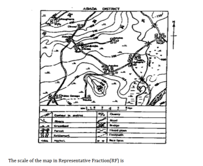
What is the highest contour line in the mapped area?

  • A. 400 metres
  • B. 600 metres
  • C. 500 metres
  • D. 300 metres
View Answer & Discuss JAMB 2025
72

The scale of the map in representative fraction(RF) is 

  • A. 1:100,000
  • B. 1:50,000
  • C. 1:25,000
  • D. 1:200,000
View Answer & Discuss JAMB 2025
73

An example fossil fuel is

  • A. coal
  • B. clay
  • C. granite
  • D. sandstone
View Answer & Discuss JAMB 2025
Your School's Whatsapp Group - Join Us now
WAEC and NECO CBT App for Mobile Devices - Candidates, Schools, Centres, Resellers - 100% Offline -Download Now
WAEC and NECO CBT Software for Computers and Laptops - Candidates, Schools, Centres, Resellers - 100% Offline -Download Now
74

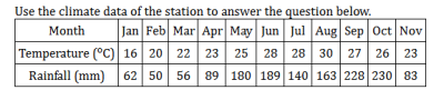
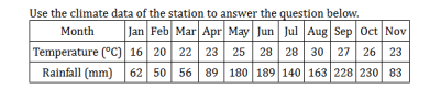
Which month in the station has the highest rainfall?

  • A. July
  • B. September
  • C. January
  • D. October
View Answer & Discuss JAMB 2025
75

What is the annual rainfall for station X?

  • A. 1160 mm
  • B. 1461 mm
  • C. 1504 mm
  • D. 1511 mm
View Answer & Discuss JAMB 2025
Start a Free Practice Test
 
WAEC and NECO CBT Software for Computers and Laptops - Candidates, Schools, Centres, Resellers - 100% Offline -Download Now
Your School's Whatsapp Group - Join Us now
Post-UTME Past Questions - Original materials are available here - Download PDF for your school of choice + 1 year SMS alerts
Post UTME Past Questions Agent