(a) Define climate
(b) With the aid of a diagram, describe how latitudes influence temperature
(c) Calculate the temperature at a coastal mountain peak of height 6000 metres when the temperature at sea level is 40ºC


(a) Climate is the average weather condition of a place taken over a long period of time usually between 30 - 40 years.
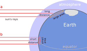
(b) temperature decreases from equatorial regions to poles, band of rays from the sun falls vertically over the equatorial region. This band travels through a very short distance at the same time, this band falls or heat up a smaller surface area, this results in the equatorial regions being hotter , the sun's rays fall obliquely on the surface in the temperature latitudes, this band travels a longer distance and much of the heat is lost to clouds, water vapour and dust particles, the rays in the temperate latitudes heat up a larger area than that of the tropics, this results in the temperate latitudes having lower temperatures
(c) Lapse rate is 6.5ºC for every 1000m of ascent.
6000m will have a lapse rate of (6.5 X 6000)ºC 1000 = 39ºC
temperature at sea level = 40ºC
temperature at height 6000m will be (40 - 39)ºC = 1ºC


Contributions ({{ comment_count }})
Please wait...
Modal title
Report
Block User
{{ feedback_modal_data.title }}